by Abby Graf
As the snowstorm headed through New York on February 24, one professor at Stony Brook University in Stony Brook, New York spent the hours leading up to it preparing his students to head right into the storm.
Brian Colle, atmospheric science professor at Stony Brook University, is part of many operations in NASA’s Investigation of Microphysics and Precipitation for Atlantic Coast-Threatening Snowstorms (IMPACTS).
Whether it’s preparing a team to operate radars and mobile trucks, launching weather balloons, or flying in the cockpit of one of two aircraft used in the experiment, Colle’s job deals with the fun of coordinating and communicating, and the heart of the mission: science. IMPACTS aims to understand the precipitation mechanisms within snowstorms. The campaign uses two aircraft, ground-based radars, weather balloons, computer simulations, and airborne instruments to help answer questions about how snowstorms form and develop, and how to better predict them.
“One of my jobs is serving as the liaison between the teams,” said Colle. “We start with a briefing the morning of, then I’m making sure I know the plan of the day. I’m coordinating, sending emails, making sure the radar truck is ready. As the mission goes along, I’m in contact with the teams the whole time, making sure we’re collecting data. The job isn’t finished until the storm is over.”
Using Mobile Radar Trucks at Key Locations to Capture Data
Colle sent teams of students out midday on February 24 to prepare for the overnight storm. One of the teams operates the mobile radar truck that has a Skyler-2 radar on it, which sends out pulse signals every few seconds to collect observations about the atmosphere from lower altitudes, providing high-resolution data from the large geographic regions it samples. “This is the next generation of radars; [helping us] understand rapid storm evolution,” said Colle.
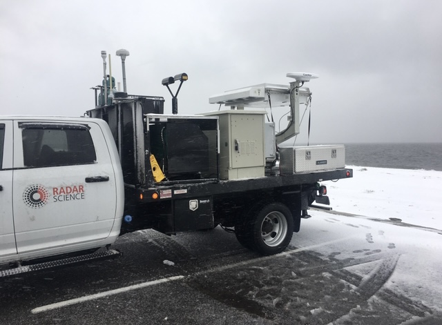
The truck is also outfitted with a Parsivel instrument, which is a vertically pointed radar that samples the sizes of snowflakes or raindrops, along with a standardized weather instrument package including thermometers, gauges, pressure sensors, and more. Some of the team headed up to the storm hours before it began to find a location with good visibility in all directions. The goal is to have an area where trees and buildings are not blocking the sensing instruments. While collecting data would’ve begun around 1 a.m., internet issues prevented the team from getting the experiment running, but they have collected a great amount of data from past storms.
Launching Weather Balloons in the Depths of the Storm
Back at Stony Brook University, Colle organized a group of students to launch weather balloons on campus to measure temperature, pressure, and humidity at different altitudes. An instrument package is attached to the balloon and can “communicate” with a computer on the ground, sending data back as the balloon rises in the air.

These balloons are launched from a radar truck, which is also equipped with instruments to measure snowflake characteristics. The team started collecting data hours before the two aircraft reached the storms. The P-3 aircraft flies directly into the storm, with instruments aboard to collect data and images from various altitudes. This gives scientists a deeper look at the microphysical properties of the storm, while the ER-2 aircraft flies at roughly 65,000 feet, capturing data with six remote-sensing instruments from above the clouds. The ER-2 arrived at the storm around 4:30 a.m., but the P-3 faced mechanical issues that delayed its launch until the morning of February 25.
The Full Flight Experience
Though not on the P-3 flight this time around, Colle has had the opportunity to fly in the cockpit of the aircraft a few times the past two months, including the February 17 snowstorm in the Chicago area. This falls under his one of many roles but is one of the reasons he joined this mission early on. Interested in studying snowstorms for years, being in the cockpit of the plane during these storms is a lot of fun for Colle. He’s the mission scientist when on the plane, helping interpret the data collected, modify flight tracks, communicate any changes to the pilots, and helping with coordinating the instruments on the plane to make sure everything is functioning and communicating.
One of the lessons he’s learned is how the pilots navigate the busy airspaces. In populated areas like Chicago or New York, there are a lot of planes taking off, flying, and landing, requiring the pilots to coordinate where the aircraft is headed. It requires a team effort to figure out how to best orient the aircraft.
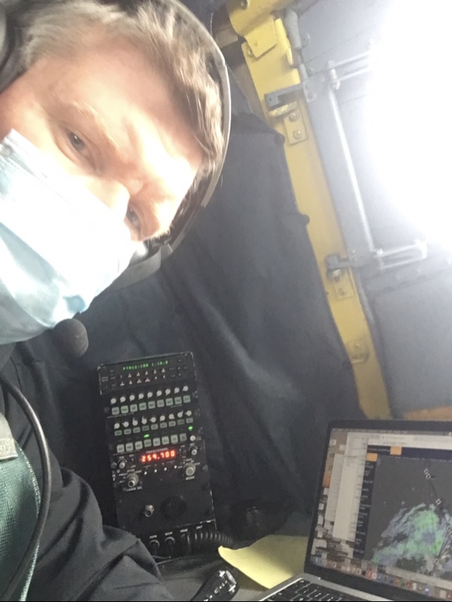
“It’s awesome to be a part of the mission. For many years we didn’t have these opportunities. In the past, I’d take measurements on the ground, collecting snowfall and looking under a microscope at the crystal shapes and habits. Looking at data in real-time, looking out the window, and then interacting with the pilots and hearing what they have to deal with…it’s a continuous science experiment and participating in regions we haven’t sampled before has been very exciting,” said Colle.
As IMPACTS winds down its science experiments this winter, Colle and the rest of the team are looking forward to their opportunities next time around. Winter storms aren’t always the easiest to sample, and the scientists are constantly learning. But the instances in which challenges and difficulties occur only make Colle more confident that the data collected this year will give them better opportunities for improvement next year.